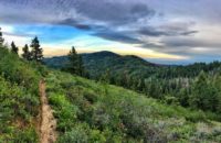
Gardner Peak Trail
For hardy adventurers only, Gardner Peak is one of the few trails that explores the backside of the Boise ridge. It is a multi-use motorized trail, partially double track, mostly rugged single track. Few bikers or hikers are hardcore enough to access and complete this trail, which means that it sees less use, and less maintenance, than most trails. As a result, it can be overgrown. Also, the southern leg of the trail has essentially merged with Daggett Creek, making it scarcely a trail. Instead of using this part of the trail, follow the Gardner Peak trail all the way down to Clear Creek Road, make your way to Crooked Summit on Clear Creek Road, and then climb back up to Eagleson Summit on forest road 263 (Boise Peak Rd). I know, I know, it’s complicated. That’s why Gardner Peak is experienced only by a brave few.
Recent Trail Reports
September 28, 2024 at 10:39 pmRode the south section heading west. Creek was low enough to avoid wet boots. Not too much overgrowth, good condition overall for this time of year. Fun trail.
October 26, 2019 at 3:51 pmVery over gown, basically running the gauntlet with all the brush. If you're going clockwise, the last half of the trail is *in* Daggett Creek.There a ridable sections but most of it is hike-a-bike. For over a mile. We passed some guys on motorcycles who said the water is apparently lower this time of year. It was very wet and our shoes got soaked.
September 23, 2019 at 7:13 amMost of this trail is easy to run and the views are beautiful. It appears someone rode in and cut back a lot of the overgrowth making it easier to navigate only to leave some of it on the trail causing trip hazards. What the description doesn't say, is the trail disappears into an ankle-deep creek that you need to wade through to get back on course (unless I went completely off-track somewhere). Wet shoes and a steep climb out, made the last couple of miles tough.
August 21, 2018 at 2:37 pmVery overgrown. Not worth it in this condition--it was a suffer-fest.


Rode the south section heading west. Creek was low enough to avoid wet boots. Not too much overgrowth, good condition overall for this time of year. Fun trail.
Very over gown, basically running the gauntlet with all the brush.
If you’re going clockwise, the last half of the trail is *in* Daggett Creek.There a ridable sections but most of it is hike-a-bike. For over a mile. We passed some guys on motorcycles who said the water is apparently lower this time of year. It was very wet and our shoes got soaked.
Most of this trail is easy to run and the views are beautiful. It appears someone rode in and cut back a lot of the overgrowth making it easier to navigate only to leave some of it on the trail causing trip hazards. What the description doesn’t say, is the trail disappears into an ankle-deep creek that you need to wade through to get back on course (unless I went completely off-track somewhere). Wet shoes and a steep climb out, made the last couple of miles tough.
Very overgrown. Not worth it in this condition–it was a suffer-fest.